111
 2
 3
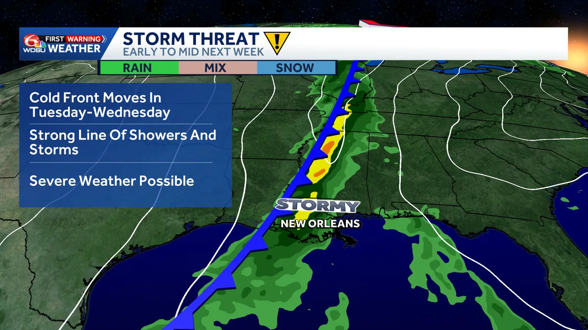
NEW ORLEANS, LA — A storm system tracking across the country next week could set up a round of active weather across parts of the southern United States, including the possibility of severe thunderstorms. Forecasters say the pattern is worth watching even though the details are still coming into focus.
The latest outlook points to a late Tuesday into Wednesday window, but that timing could shift as meteorologists get a better handle on how the system behaves. The Storm Prediction Center says trends will be monitored for increasing severe potential across the south-central U.S. early next week.
For now, the main message is caution rather than certainty. Residents across the South are being urged to follow forecast updates closely as the setup evolves.
The Storm Prediction Center has highlighted the southern tier of the country as an area to monitor as the storm system advances. That does not mean severe weather is guaranteed, but it does suggest the ingredients may become more favorable.
Meteorologists say confidence is still limited because the atmosphere can change quickly in the days leading up to a storm. Small shifts in temperature, moisture and wind can affect whether storms remain scattered or become more organized.
At this stage, forecasters are using the phrase “increasing severe potential” because the signal is growing, but not yet sharp enough to pin down exact impacts. The next several forecast cycles will help narrow down where the most concerning storms could form.
The best chance for active weather appears to be late Tuesday into Wednesday, according to the current outlook. That timing is only a target for now, and forecasters say it could move as the system comes into better focus.
One scenario under consideration is the development of a line of thunderstorms as the front or storm system moves through. This kind of setup is sometimes called a squall line, and it can produce an organized band of storms rather than isolated cells.
It is too early to say whether that exact pattern will develop. It is also too early to determine which communities would face the greatest risk if the line does form.
Forecasters say the specific hazards will depend on how the storm system interacts with the surrounding atmosphere. If the ingredients align in the right way, storms could become stronger and more widespread.
But the current forecast does not yet identify the most likely threats or their severity. That means it is not possible right now to say whether damaging wind, hail or other severe weather will be the biggest concern in any one area.
The uncertainty is why meteorologists are emphasizing monitoring over precision. The setup has enough potential to merit attention, but not enough clarity to support a detailed local forecast this far out.
Behind the storm system, a much cooler air mass could move into the region. That would bring a noticeable change after the active weather passes, assuming the system follows the current broad forecast track.
The arrival of cooler air is part of the larger pattern forecasters are watching. Storm systems that move through the South in spring-like fashion can be followed by a sharp drop in temperatures once the front clears the area.
For residents, that means next week may feature more than one weather shift. The potential for thunderstorms comes first, with cooler conditions possibly close behind.
Because the forecast is still developing, meteorologists are asking people across the southern United States to pay attention to updates rather than fixating on a single scenario. The storm system could evolve in several different ways before it reaches its peak impact.
That includes changes in timing, location and storm intensity. Each of those factors will help determine whether the region sees isolated thunderstorms, a broader line of storms or a quieter outcome than current guidance suggests.
For now, the message is simple: keep an eye on the forecast through the weekend and into early next week. Confidence should improve as meteorologists get closer to the late Tuesday into Wednesday period.